Pallikaranai Ramsar: Revised Interim Zone of Influence Filed in Madras High Court
The Tamil Nadu State Wetlands Authority has told the Madras High Court that the Pallikaranai Ramsar site's zone of influence should be 36 named survey numbers covering about 128 hectares, with construction regulated rather than banned. That is a very different picture from the continuous 1 km ring in CMDA's October 2025 order. This page sets out what the filing says, what it does not decide, and what owners and buyers near the marsh can do now.
Status today: this is a proposal filed in court, described by the Authority itself as interim and not the final delineation. We have not seen any court order adopting it, and CMDA Office Order No. 07/2025 is the last order we have seen. Treat the 1 km map as still operative until CMDA or the court says otherwise.
What Was Filed
The document is a Status Report affirmed on 9 October 2026 by the Member Secretary of the Tamil Nadu State Wetlands Authority in W.P. No. 7120 of 2026. The petitioners are CREDAI Chennai, Olympia Tech Park (Chennai) Private Limited and Navin Housing and Properties Private Limited. The respondents include CMDA, the District Collector of Chengalpattu, the Department of Environment and Climate Change, and the Authority itself. According to the report, about a dozen related writ petitions on the same subject have been tagged with it.
How It Got Here
- An earlier status report on a proposed interim zone of influence was filed in compliance with the court's order of 4 August 2026.
- The petitioners then made suggestions in court, and the Authority received 23 representations from landowners, developers and others around the site.
- Under the court's order of 7 September 2026, the Authority held a meeting with officials and technical agencies on 30 September 2026 and reworked the zone.
The representations asked for four things: exclusion of privately owned patta land, reconsideration of particular survey fields, recognition of existing developments and permissions, and regulations that distinguish between the wetland boundary, the zone of influence and developed private land.
What the Revised Zone Looks Like
The Authority says it re-examined each parcel for hydrological connectivity, drainage pathways, satellite wetlands, existing infrastructure, land use and the wetland-urban interface, and reviewed historical Google Earth imagery for water spread, low-lying areas, drainage channels and built-up land. The result is 36 survey numbers, about 128.19 hectares, that it says "can likely have an impact on the hydrology" of the site.
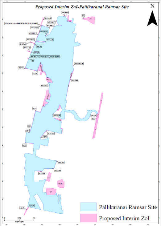
The same map over satellite imagery, which shows the surrounding roads and buildings:
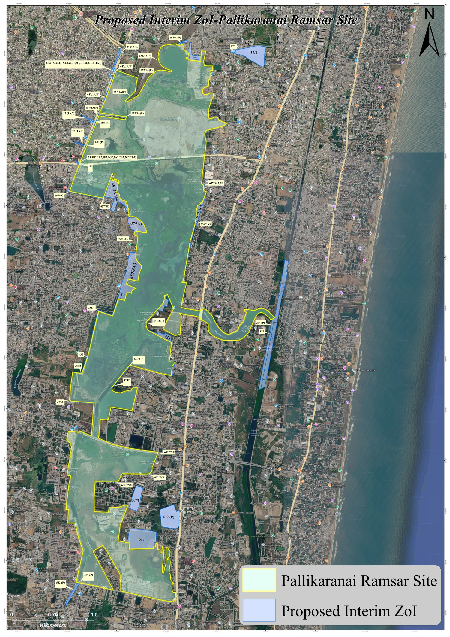
The shape matters. On this map the zone is a set of individual parcels, mostly along the marsh edge, plus a few detached ones such as 57/1 in Perungudi and the long strip near the Buckingham Canal. It is not a continuous band around the site, which is how the 1 km zone in the CMDA map reads. Compare the two maps for your own parcel rather than assuming either way.
Survey Numbers in the Proposed Interim Zone
All are in Sholinganallur taluk, Chennai district, except Perumbakkam. "(P)" means part of the survey number. Matching on survey number alone is not enough, since the same number can exist in several villages, so match village and number together, and check the sub-division against your patta.
| Village | Survey numbers |
|---|---|
| Injambakkam | 283; 284(P) |
| Karapakkam | 175(P); 177; 189 |
| Okkiyam Thoraipakkam | 407(P) |
| Pallikaranai | 23 (1A, 2); 55 (1D2, 1E2, 1F2, 1G2, 2A2, 2B2, 2C2, 2D2); 80; 429/2; 429/3; 430; 431/2(P); 432/1; 433; 434/3; 453/2C; 657 (1A, 3A1, 3A3, 3A4, 3F, 3G, 3H, 3I, 3J, 3K, 4A3); 657/1A(P); 657/1B3; 657/3A2, 3B; 657/3A3; 657/3A5; 657/4C; 658/1A(P); 658/1B; 688(P); 690(P); 691 |
| Perungudi | 57/1 |
| Sholinganallur | 439(P); 507/1; 527; 602/7&8 |
| Perumbakkam (Tambaram taluk, Chengalpattu district) | 537(P); 542(P) |
The list is transcribed from a scanned annexure, so please check it against the filed report or the Authority before relying on it for a transaction.
Construction Would Be Regulated, Not Banned
The Authority's position is that construction "need not necessarily be absolutely prohibited" across the zone, and should be regulated on site-specific scientific and hydrological grounds. The safeguards it proposes inside the interim zone are:
- No blocking, diversion or obstruction of established inlet and outlet channels, natural drains or hydrological pathways.
- No dumping of solid waste, construction and demolition waste or other waste in drainage pathways.
- No discharge of untreated sewage, effluent or wastewater into watercourses connected with the wetland.
- No permanent alteration of established hydrological connections.
- No Red Category industries with high pollution potential.
- For construction, a No Objection Certificate from the District Level Wetlands Management Committee, under the proposed regulatory mechanism.
The report does not describe how that mechanism or the NOC would work, and it does not say how it fits with CMDA Office Order 07/2025.
What Is Still Undecided
- It is interim. The Authority says the final zone will be fixed after scientific and cadastral exercises and ground-truthing under the Wetlands (Conservation and Management) Rules, 2017, and its guidelines.
- The court has to accept it. We have not seen the court's response to this report or the outcome of any hearing after it was filed.
- The CMDA order is not addressed. The report does not say whether CMDA will withdraw or amend its 1 km order, or when. Parcels outside the 36 numbers but inside the old yellow area stay unconfirmed until CMDA says in writing.
What Owners and Buyers Can Do Now
| Your parcel | Position on the papers | Practical step |
|---|---|---|
| On the 36-number list | Proposed to be in the interim zone, where development would need the safeguards and an NOC. | Note it in your records and plan for the NOC. Do not assume approval is easier until an order says so. |
| In the old 1 km map, not on the list | CMDA's October 2025 instruction still stands on its face. The proposal would leave you outside the interim zone, but it is not adopted. | Ask CMDA in writing how it will treat your application. Hold major spending until the position is clear. |
| Selling or buying | Both maps may be asked about, and the answer can change after a hearing. | Record the survey number against both maps in your file, and say so in the agreement or valuation. |
| Loan or bank review | Each bank sets its own policy, and none has been told to follow a proposal. | Ask your bank how it treats the zone now, and bring the filing and the CMDA reply. |
How This Affects a Valuation Report
A report on a parcel near the marsh should record the survey number against the Ramsar boundary, the CMDA 1 km map and, now, this proposed interim zone, and state which assumptions it relies on. If the parcel is on the list, the likely need for an NOC and the safeguards above are limiting conditions that a willing buyer would weigh. A report cannot confirm that an approval will come or predict how the court will decide, and I will not say otherwise.
Is your survey number on the list?
Send me your village and survey number and I will check it against both the CMDA map and the proposed interim zone, and tell you plainly where it stands.
This page is a plain-language summary of a court filing and is not legal advice. For anything with money or a deadline attached, please also speak to your advocate. I will update it when the court or CMDA changes the position.